Historical Evidence Reinforces Seattle Fault Tsunami Threat
July 28, 2012 U.S. Geological Survey’s Brian Atwater has found evidence of a powerful tsunami near Bremerton recently – due to an earthquake which was “much more dangerous than previously thought”. Their conclusion: climb to safety after an earthquake.
Unmanned Drones for Disaster Response?
July 27, 2012Funny that DHS is getting criticism for NOT using drones, when my take is that drones further compromise our civil freedoms, but apparently their use helps some key corporations' bottom lines – and their use can be more palatable by using them for Disaster Response.
Read MoreFEMA’s new web-based, independent study training course for citizens and businesses-- IS-325—Earthquake Basics-- Science, Risk, and Mitigation
July 26, 2012 As they indicate below, this appears to be a pretty basic course, but by clicking on one of the initial pages you can see much of the complete course outline and quickly skim it to see how much of it is applicable to your family or business.
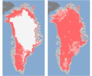
NASA-- Sudden massive melt Greenland
July 26, 2012 According to an interesting AP report, “Nearly all of Greenland's massive ice sheet suddenly started melting a bit this month, a freak event that surprised scientists.
Major modern-era Puget Sound earthquakes
July 23, 2012 The University of Washington Seismology Lab, has released a new map of major semi-recent quakes and fault lines around Puget Sound.
