San Juans CenturyLinks Fiber Optic Cable Cut - No 911 Service
November 7, 2013Similar to what happened on Vashon several years ago, CenturyLink’s main fiber optic cable to the San Juan’s got severed Tuesday and has cut 911 service to Lopez, Shaw and Orcas islands – with no estimated restoration time. See the report at: www.kirotv.com/news/news/thousands-san-juans-unable-call-911/nbkKn/ for more details.
Read More1st Regional Climate Assessment Update Since 1999-- Grim News
November 5, 2013 The Northwest faces poorer forest health (more forest fires), earlier snowmelt (lower stream flows) and raised sea levels (eroding coasts), according to Monday’s release of the Northwest Climate Assessment Report (NWCAR, 2013). Impacts might total some $14 billion dollars regionally.
VashonBePrepared Celebrates 6th Anniversary with Community Summit
October 22, 2013VashonBePrepared Community Summit
 Leaders from the Vashon community came together for the first VashonBePrepared Community Summit Saturday morning at Chautauqua School. Moderated by President Rick Wallace and Vice-President Bob Smueles, the group brainstormed for over 3 hours on current community need if a disaster were to befall us.
CREW Releases New Cascadia Earthquake and Tsunami Scenario-- 10-15% chance in 50 years that 10K Might Die in a $49 Billion 9.0 Cascadia MegaQuake
October 19, 2013 On January 26, 1700 an estimated M9 earthquake unzipped the 700+ mile Cascadia Subduction Zone fault from northern California, USA to southern British Columbia, Canada, much like recent events in 2011 in Japan and 2010 in Chile. The newly released “Cascadia Subduction Zone Earthquakes: A Magnitude 9.0 Earthquake Scenario” examines how the Pacific Northwest may fare after the next great ‘megathrust’ earthquake and tsunami. “The new report conveys the most current scientific and emergency planning information accessible to a wide variety of audiences.” said Tamra Biasco of the Federal Emergency Management Agency, one of the lead authors.
Your chance to comment on transportation needs
September 17, 2013
Only Tier 1 Roads (i.e., Vashon Highway) May Be Plowed
September 13, 2013
NATIONAL PREPAREDNESS MONTH, 2013
September 10, 2013BY THE PRESIDENT OF THE UNITED STATES OF AMERICA
A PROCLAMATION
West Coast Ports Could Suffer from Alaska Tsunami
September 5, 2013 | ||
Maximum current speeds for the Port of Los Angeles (POLA) and the Port of Long Beach (POLB), according to the SAFRR Tsunami Scenario. In the POLA, currents are strongest at Angels Gate, the Cabrillo Marina, the Boat Yard, and the old Navy Yard. Once the tsunami event is underway, navigation through the Gate would be very dangerous. In the Cabrillo Marina and Boat Yard, currents are likely strong enough to break apart floating docks, damage piles, and pull small vessels from their mooring lines. The strongest currents are found in the old Navy Yard; however there are no exposed floating assets in this immediate area. At the POLB, again strong currents are found at the Gate. Also in the POLB, strong and jet-like currents are predicted at the entrance to the main cargo container area (Pier J). Currents here may be strong enough to damage, and possible break, mooring lines. Photo Credit: SAFRR Tsunami Scenario. (Larger image) Read Moretaxonomy-card: 1st Use (in CA) of the Wireless Emergency Alert ProgramAugust 7, 2013
taxonomy-card: Lloyds Posits Cost of Next Large Coronal Mass Ejection at $2.6 TrillionJuly 15, 2013
taxonomy-card: Crowdsourcing is Cheaper Way to Learn of EarthquakesJuly 11, 2013
taxonomy-card: WMO Distinguishes Long-term Climate Change from Short-term Natural VariationJuly 5, 2013
taxonomy-card: 1st Seattle Bicycle Disaster Relief Trial HeldJune 24, 2013
taxonomy-card: 2012 was 2nd Most Expensive Disaster Year-- $110 Billion in DamagesJune 21, 2013
taxonomy-card: 107 Tornados have been Recorded over Washington–Some in the Puget Sound RegionJune 17, 2013
taxonomy-card: Red Cross free Wildfire App joins their First Aid, Hurricane and Earthquake AppsJune 17, 2013
taxonomy-card: Washington State Seismic Hazards CatalogJune 14, 2013
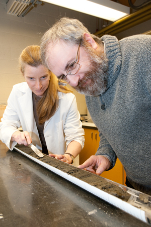
taxonomy-card: New Report Confirms Past Cascadia Megaquakes at Barclay Sound’s Effingham Inlet-- Reinforces Prognosis for Upcoming Megathrust EarthquakeJune 14, 2013Canadian scientists apply new methods to better understand Pacific coast earthquakes
taxonomy-card: Open Invitation to Vashon Maury Island Radio Club’s Field Day 2013-- June 22 & 23June 14, 2013
taxonomy-card: taxonomy-card: Free Jan 30th Webinar-- Reducing the Risks of Nonstructural Earthquake Damage (FEMA E-74)January 24, 2013
taxonomy-card: New Volunteerism Video Highlights Vashon’s Daniel Luechtefeld’s Big SaveJanuary 20, 2013
taxonomy-card: 2012 Episodic Tremor and Slip (ETS) Activity Leads to Speculation About 2013 NW EarthquakesJanuary 3, 2013
|
 Wireless Emergency Alerts (WEAs) provide free notifications of imminent threats to safety or missing persons to your mobile device. In order to receive WEAs, you must have a capable device and be located in an area (e.g., county) targeted by Authorized Senders to receive one of 3 types of alerts:


 The
The 


 Understanding the size and frequency of large earthquakes along the Pacific coast of North America is of great importance, not just to scientists, but also to government planners and the general public. The only way to predict the frequency and intensity of the ground motion expected from large and giant "megathrust " earthquakes along Canada's west coast is to analyze the geologic record.


